The Bank of The River Gambia have been inhabited for many centuries.
Hanno, The Carthaginean, referred to Gambia while writing about his voyage to West Africa in 470 B.C. It is known that between
the 5th and 8th centuries most of the Senegambian Area came from the Sarahuley ethnic group, and those descendants can be
found in The Gambia.
The Ghana Empire which had its capital in present day Mauritania,
soon gave way to the Songhais, who latter became Muslims and promoted their new faith zealously. Around the 13th century,
however, Mandingoes and Susus' from the Futa Jallon Plateau had established themselves in what is now Mali, and from there
controlled the whole of The Gambia Basin. The Gambia was then inhabited mainly by wollofs on the Northern bank and Jolas on
the southern bank of the River. When the Mali Empire declined at the end of the 16th century, the Mandingo leaders retired
to the Futa Jallon, but continued to have influence over the Casamance (Southern Senegal) and The Gambia until early in the
18th century. Later The Fula invaders penetrated the region. The Ancestors of the Fulas had come from Africa and earlier had
founded the famous Emirates of' Northern Nigeria.
During the 18th and 19th centuries, there were protracted wars between
the Islamic Marabouts and the Pagan Soninkis. The British, who already established themselves at Banjul by this time, offered
protection to the various chiefs during these conflicts, and through treaties, soon brought The Gambia region under their
control.
Before the British, some Portuguese had come to The Gambia following
the expeditions promoted by Prince Henry starting in 1455. They had introduced groundnuts, tie main cash crop of today, cotton,
and some tropical fruits from Brazil. Their number, however, was never large and the, were soon absorbed by intermarriage.
The British started trading with the Gambians in 1587, and within
a few decades had explored the River. They traded as business companies and ruled the area from their fort on James Island
until 1765, when the Gambia was made a part of the British colony of SeneGambia with its headquarters at St. Louis. When in
1807, slave trading was abolished, James Island was used to check and stop the illicit traffic in slaves. In 1816, Captain
Alexander Grant obtained the sandy bank of Banjul Island by a treaty from the Chief of Kombo and built the planned city of
Bathurst, now renamed Banjul. Bathurst already had a civilian population of 700 by 1818, the year that civil government was
begun. The Gambia was administered as a crown colony from Sierra Leone between 1821 and 1892, but since then Banjul (Bathurst)
has been its capital.
The Gambia became independent in 1965 and five years later adopted
a Republican Constitution.
Local
Climate
The Gambia is generally recognized as having perhaps the most agreeable
climate in West Africa. The weather is subtropical with distinct dry (7 Months) and Rainy seasons.
There is a dry wind called the Harmattan which blows
during the dry season. The Harmattan Sahara winds give the Gambia a uniquely pleasant winter, completely rainless and blessed
with daily sunshine. From November to May, the temperature varies between 70oF (21oC) and 80oF
(27oC) and the relative humidity stays between 30% and 60%. Summer temperatures range between 80oF (27oC)
and 90oF (32oC) and the relative humidity is high. The rains begin in June and continue to October,
conceding with the warmer weather. Inland, the cool season is shorter, and by the day high temperatures are encountered between
March and June. Generally, there is considerable cooling off in the evening. Rainfall in most parts of the country does not
exceed 40 inches (1,016 Millimeters) and sunny periods occur on most days even in the rainy season.
|
 |
|
|
The Gambia National Anthem
Listen to it by clicking here
For The Gambia, our homeland, we strive
and work and pray,
That all may live in unity, freedom and peace each day.
Let justice guide our actions towards the
common good,
And join our diverse peoples to prove man's brotherhood.
We pledge our firm allegiance, our promise we
renew;
Keep us, great God of nations, to The Gambia ever true.
- Adapted from the traditional Mandinka
song 'Foday Kaba Dumbuya -
A major attraction for the visitor to The Gambia, this great West
African River rises in the Futa Jallon highlands nearly a thousand river miles away in the Republic of Guinea. It crosses
Eastern Senegal before entering Gambian territory some 300 miles (480 Kilometers) inland. In The Gambia, The River is the
dominating features and provides both a useful means of transportation and irrigation as well as a rich ground for fishing,
boating and sailing.
The River Gambia is several miles wide at its mouth near Cape St.
Mary and has a bar with a depth of 27 feet (8. 1 Meters) . It narrows to three miles (4.8 Kilometers) at Banjul where the
ferry to Barra operates. Ocean-going vessels up to about 3,000 gross registered (241 Kilometers) to Kuntaur. The River is
also navigable to steamers for 140 miles (225 Kilometers) farther upstream.
For the first 80 Miles (129 kilometers) inland from Banjul, The River
Gambia is fringed with mangrove-covered banks, which give way to red ironstone cliffs crowned with a tangle of green vegetation.
Farther up River, the ironstone cliffs give way to banks of waving grass and parklands. The whole River and the numerous creeks
(locally known as 'Bolons') which join it, are fascinating to the bird lover and the student of nature: Hippopotami, Crocodiles
and Dog-faced baboons are often seen.
In the past, The River's fame lay in the fact that, for sailing vessels,
it was navigable at least as far as the country's eastern boundary; It is one of the finest waterways in West Africa. More
recently, it has become the target for government development plans including an extension to the Port of Banjul. Fisheries
development, Hydrological Surveys, a rice development project and even a feasibility survey for a bridge-barrage building
program at the Trans-Gambia Ferry crossing near Farafenni. The Bridge-Barrage Project is to be a joint venture by the Senegalese
and Gambian Governments.
In addition to Ferries, ships and cutters loaded with groundnuts,
the country's main export crop, can be seen plying up and down the River, and dugout canoes used by fishermen are also a common
sight, Their existence-,. however, does not diminish the serene, tranquil beauty of the Great River flowing majestically westward
into the Atlantic Ocean. Like there forerunners, the men-of-war and the slave ships which fought battles and went this way
in years, these river craft only add to the Gambia's colourful beauty.
Please Visit Related Websites Below
|
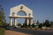
| *****Arch 22***** |
|
| Arch22 & Airport |
|
|
|
|
Geographical
Features
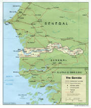
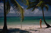
Situated on the Atlantic Coast at The Bulge of West Africa, The Gambia
has an area of some 4,000 square miles (10,360 square kilometers) extending eastward from the sea for some 300 miles (480
kilometers) along both banks of The River Gambia. Near the mouth of The River, the country is over 30 miles (48 kilometers)
wide but further upriver the width diminishes to 15 miles (24 kilometers). On The Coast, it meets -the Atlantic with impressive
sand cliffs and sports miles of unspoiled palm fringed beaches. It borders with the Republic of Senegal on the landward sides.
The country is mostly a low Plateau which decreases in height as it
nears the Atlantic Coast. The Plain is broken in a few places by low flat-topped hills and The River Gambia and its tributaries.
The area extending from MacCarthy Island, where Georgetown is located, to the Eastern end of the country is enclosed by low
Rocky Hills which appear to be volcanic. The soil, especially in the Kuntaur District, is clay along the Banks of The River,
but elsewhere are alluvial soils, red, brown and gray sands, some gravel and isolated ironstone rocks. The Coast and River
Banks consist largely of Mangrove swamps, and the lower part of the River has steep banks which are covered with tropical
forest, Bamboo being characteristic. Away from the River, there is wooded grassland, for the Gambia is in the Savannah Region
of West Africa.
The country's narrow width and the large River that drains it have,
however, given it more of a parkland look, with large areas covered by a variety of trees such as Mahogany, Rosewood, Oil
Palm and Rubber. The Forestry Division of the Ministry of Agriculture, in addition to carrying out conservation measures,
also does a brisk trade in local woods.
The country can be reached by sea, land and air. There are scheduled
and charter flights to and from western Europe with connections to other parts of the world. Some cargo vessels that make
regular calls at the port of Banjul contain a few passenger cabins.
For visits of short duration, tropical clothing and a few personal
effects will be adequate. Most requirements may be purchased in the country if a longer stay is anticipated.
The Gambia has reciprocal arrangements with many countries, either
on bilateral agreements or through membership of certain organizations, whereby citizens of those countries do not require
a visa for a period of stay of less than three months. These include the member countries of ECOWAS, all Commonwealth countries,
Denmark, Finland, Iceland, the Netherlands, Norway and Sweden.
Nationals of other countries should apply for a visa to a Gambian
diplomatic mission or consulate abroad. A visa can also be obtained from British consular offices in countries where there
is no Gambian diplomatic or consular representation.
Business travelers, particularly during the tourist season (October-April)
should make hotel reservations prior to their departure for the Gambia.
An airport tax of $20 is levied on travelers leaving the Gambia by
air.
The Gambia's only mandatory health requirement is a yellow fever vaccination.
Anti-malaria medication is recommended.
The Gambia Public Transport Corporation offers an -extensive and low-cost
public transportation system through a bus service that interlinks all towns throughout the country.
Taxi cabs of the saloon type are generally available and prices are
negotiable depending on distance and time. Car rental agencies offer services for unlimited mileage, so long as one presents
a passport and driving license.
|
|
|
|
|


